|
Negli
ultimi venti anni l'istituto Californiano di Tecnologia
nel laboratorio di Propulsione Jet è divenuto uno dei
primi centri mondiali per la ricerca sulla
determinazione di orbite precise.
Il
gruppo GPS Navcom Technology e JPL hanno creato un
sistema per operare in tempo reale per produrre
correzioni DGPS di alta precisione per ricevitori di
navigazione GPS a doppia frequenza.
Il
sistema attualmente opera usando una rete di 28 centri
di calcolo e ricevitori sparsi in tutto il mondo, che
fanno parte della Rete di controllo GPS a Terra (CGN)
NASA/JPL.
Mentre
il sistema di StarFire attualmente produce solo le
correzioni di clock per ogni satellite, il sistema JPL
genera clock e le correzioni dell'orbita per ogni
satellite come pure correzioni della troposfera per i
siti del riferimento.
Indirizzando
tutte le sorgenti di errore del WADGPS, il sistema JPL
fornisce la massima precisione di navigazione e un
singolo set di correzioni mondiali per i tutti
satelliti.
JPL
ha pubblicato numerose documentazioni tecniche circa il
sistema e la tecnologia. Il sistema di correzione e gli
algoritmi trattati sono chiamati Real Time Gipsy (RTG).
John
Deere, attraverso Navcom, ha ottenuto da JPL la licenza
esclusiva della tecnologia Real Time Gipsy (RTG),
incluso software ed algoritmi.
John
Deere, attraverso Navcom, ha perfezionato un contratto
con JPL e NASA per l'uso dell'intera rete a terra di
controllo GPS (CGN).
Il
successo di questo progetto è l'integrazione di tutti
questi elementi e tecnologie differenziate nel sistema
STARFIRE, che, già oggi, è in grado di garantire
precisioni sempre inferiori a 10cm, in coordinate
assolute WGS84, in qualsiasi parte del mondo in tempo
reale.
Prove
sviluppate nel mese di Giugno 2002 (con il sistema
operativo solo al 70%) in 30 posizioni di coordinate
note, sparse in ogni parte del mondo, si sono
evidenziati scostamenti massimi di 7cm sulla componente
planimetrica e di 21cm sulla altimetria.
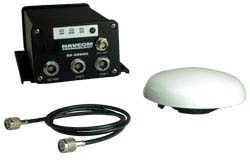
SF-2050G/SF-2050M
GIS Sensor/Machine Control Sensor
Fully
integrated StarFire DGPS sensors provide worldwide
decimeter level accuracy anywhere, anytime
NavCom's
SF-2050G and SF-2050M model receivers deliver unmatched
positioning accuracy to system integrators needing a
cost-effective, high performance differential GPS sensor.
These unique receivers use the StarFire™ Network,
NavCom's worldwide differential GPS system, for instant
decimeter-level position accuracy, anywhere in the
world, anytime.
Unparalleled
Performance The SF-2050 series is powered by proven GPS
technology, the NavCom NCT-2000D advanced GPS receiver,
which is integrated into thousands of receivers used in
agriculture, offshore, and surveying. Furthermore, it
incorporates several patented innovations advancing the
existing GPS technology to the next generation. With a
more than 50% signal-to-noise ratio advantage over any
competing technology and the combination of interference
suppression, multi-path mitigation, and measurement
accuracy, these receivers set a new standard for GPS
receivers.
Applications
The rugged and reliable SF-2050 series provide easy
integration of reliable and fast position updates into
applications such as GIS data collection, data
maintenance, ionospheric research, in-field data
verification, topographic surveys, machine control and
asset management applications. The SF-2050G is designed
for backpack GIS and mapping applications while the
SF-2050M is ideal for vehicle mounting to suit a wide
variety of machine guidance and control applications.
For
optimal performance, NavCom provides a specially
designed tri-mode antenna; however, the receiver offers
the versatility to interconnect with a variety of
antennas and other application-specific instrumentation
and configurations. The user provided mapping device
simply connects to the serial port and is ready to
receive the position data in either NMEA format or
NavCom's proprietary format.
The
receivers offer several different operating modes for
maximum flexibility and reliability. The primary mode
uses the StarFire™ differential service, for immediate
results in the field, great for navigation and
relocation of existing assets. When not operating on the
StarFire™ Network, the SF-2050 receivers offer
sub-meter position accuracy by automatically switching
to WAAS or EGNOS differential signals when available.
Optionally, the user can record "raw"
dual-frequency GPS measurements for post-processing,
back in the office.
Flexible
Interface The SF-2050 receivers are easily configured by
the provided Windows®-based utility program. For system
integrators needing maximum flexibility, the receivers
offer a binary user interface that allows complete
command and control of the GPS and L-band satellite
receivers, thus enabling customization of the interface
and receiver operation. Because the instrument can
simultaneously receive DGPS corrections in various
formats, i.e. RTCM, CMR or NavCom's proprietary format,
the receiver is able to choose the optimum data source
and provide seamless position output.
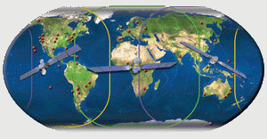
StarFire
Network The StarFire™ Network is a global subscription
service for the distribution of differential GPS
corrections providing exceptional reliability and
unprecedented accuracy of better than 10cm (4 inches).
The StarFire™ DGPS corrections are broadcast via
Inmarsat geostationary satellites, thus eliminating the
need for local reference stations or post processing.
Furthermore with the worldwide coverage of the system,
the same accuracy is available virtually any where on
the Earth's surface on land or sea from 76ºN to 76ºS
latitude.
Features
"All-in-view" tracking Global decimeter-level
accuracy using StarFire™ corrections Fully automatic
acquisition of satellite broadcast corrections Rugged
and lightweight package for mobile applications Accepts
external DGPS input in RTCM v2.2 or CMR format L1 &
L2 full wavelength carrier tracking C/A, P1 & P2
code tracking User programmable output rates Minimal
data latency 2 separate WAAS/EGNOS channels Superior
interference suppression Patented multipath rejection
Supports NMEA 0183 v3.1 messages Self-survey mode
(position averaging) CAN bus interface (SF-2050M Only)
1PPS Output (SF-2050M Only) Event Marker (SF-2050M Only)
|